Cookies help us deliver our services. By using our services, you agree to our use of cookies. Learn more.
  • Log In
  • Register
CEEOL Logo
Advanced Search
  • Home
  • SUBJECT AREAS
  • PUBLISHERS
  • JOURNALS
  • eBooks
  • GREY LITERATURE
  • CEEOL-DIGITS
  • INDIVIDUAL ACCOUNT
  • Help
  • Contact
  • for LIBRARIANS
  • for PUBLISHERS

Content Type

Subjects

Languages

Legend

  • Journal
  • Article
  • Book
  • Chapter
  • Open Access
  • Geography, Regional studies
  • Physical Geopgraphy

We kindly inform you that, as long as the subject affiliation of our 300.000+ articles is in progress, you might get unsufficient or no results on your third level or second level search. In this case, please broaden your search criteria.

Result 721-740 of 1301
  • Prev
  • 1
  • 2
  • 3
  • ...
  • 36
  • 37
  • 38
  • ...
  • 64
  • 65
  • 66
  • Next
Case Study of Insufficient Resistance to Mining Impacts of the Industrial Transport Gallery

Case Study of Insufficient Resistance to Mining Impacts of the Industrial Transport Gallery

Author(s): Wojciech Kocot,Aleksander Wodyński / Language(s): English Issue: 20/2021

The article presents an example of a transport gallery, which resistance to mining impacts proved to be not enough. In the first part of the article, there are given the principles which should be followed by this type of structures. The second part presents a of the gallery’s structure and also the analysis of the reasons for too low resistance of the objectdescription to mining influences. It has been shown that these reasons are design, execution and exploitation errors. In turn, there are presented procedures which are leading to the assurance of the resistance of the transport gallery in accordance with design assumptions. In summary, conclusions and recommendations which are formulated should be taken into account at the stage of design, erection and during exploitation of transport galleries in the industrial plants localized in mining areas.

More...
Projection of Real Mass Deformation Scenes – Intelligent Support

Projection of Real Mass Deformation Scenes – Intelligent Support

Author(s): Wiesław Piwowarski / Language(s): English Issue: 20/2021

The paper analyses the process of post-mining displacements generated by underground mining. Innovative mathematical structures for the modeling of hazard field emission were developed as strong solutions to partial differential equations in R3+1. Moreover, a stochastic equation in L2(Ω) (probabilistic space) was defined and applied as a model that takes into account the randomness of the process. Monitoring of a mining area based on solutions in the GNSS technology and classical geodesy supports the analysis of topological transformations of a given subspace. The data was archived and stored in digital form and then analyzed in many ways. The quality of the representation (measurements and modeling) was estimated with the use of incremental statistics. Thus, obtained distributions of density function are not ranked as normal distribution. The performed analyses make it possible to predict the optimal scenarios for post-mining environmental hazards.

More...
LAND COVER IMPACTS TOWARDS THERMAL VARIATION IN THE KUALA LUMPUR CITY

LAND COVER IMPACTS TOWARDS THERMAL VARIATION IN THE KUALA LUMPUR CITY

Author(s): Nurul Amirah Isa,Wan Mohd Naim Wan Mohd,Siti Aekbal Salleh,Maggie Chel Gee Ooi,Andy Chan / Language(s): English Issue: 1/2020

Physical geography and urban characteristics influence the urban climate conditions. Built-up areas, green urban parks, forest reserves, streets and terrain constitute the climatic interactions within urban areas. These have led to the variation of the urban climate condition throughout the world. Thus, in studying urban climate, the impacts of these factors are crucial to be examined. This study aims to examine the effects of six important factors, namely built-up areas, green covers, terrain elevation, building volume, surface roughness and land use type, which contribute to the variation of the urban climate condition within the Kuala Lumpur City. In this study, the effects of the six factors (urban parameters) towards the air surface temperature variation were statistically tested. Using the Weather Research and Forecasting (WRF) model and the remote sensing technique, the data needed for the analyses were extracted. The Geographical Information System (GIS) was employed as the analysis platform during the study. Based on the Spearman’s rho and Mann-Whitney U tests, it was identified that the six urban parameters and the air surface temperature variation are correlated. The further investigation conducted using the Kruskall-Wallis test has identified that only five of the urban parameters showed significant effects toward the air surface temperature variation, which are built-up areas, green covers, terrain elevation, building volume and surface roughness while the land use type was excluded. The findings of this study are very crucial as a pioneer research to integrate the urban climatic information in the urban planning decision making in tropical cities like Kuala Lumpur.

More...
APPLICATION OF FUTURE STUDIES AND SCENARIO PLANNING MODELS IN EARTHQUAKE CRISIS RESPONSE PLANNING

APPLICATION OF FUTURE STUDIES AND SCENARIO PLANNING MODELS IN EARTHQUAKE CRISIS RESPONSE PLANNING

Author(s): Hossein Hosseinikhah,Asghar Zarrabi / Language(s): English Issue: 2/2021

Future studies and scenario planning models have been applied in this investigation to formulate a useful planning for earthquake crisis response in Boyer Ahmad County, Iran, located on active faults. The objective of this study is to evaluate the vulnerable areas of urban and rural settlements, to identify the factors of casualties and losses, and to formulate the most desirable scenario in order to increase the resilience of the settlements in earthquake crisis. In this research, the vulnerable areas were detected by using the spatial analysis in ArcGIS. Cross-impact analysis and MICMAC were employed to identify the effective thrusters to reduce the financial losses of the citizens. The most desirable scenario was formulated by the Morphol scenario planning. The results indicated that about 27% of the city and 261 villages out of 977 are vulnerable to the risk. To reduce earthquake losses, a preventive scenario was outlined in order to enhance the resilience of the settlements against the earthquake crisis.

More...
COMMUNITY RESPONSE TO DISASTER MITIGATION IN THE IMPACTED AREA OF MUDFLOW DISASTER

COMMUNITY RESPONSE TO DISASTER MITIGATION IN THE IMPACTED AREA OF MUDFLOW DISASTER

Author(s): June Ekawati,Eny Sulistyowati,Gagoek Hardiman,Edward E. Pandelaki / Language(s): English Issue: 2/2022

The impact of the mudflow disaster in Sidoarjo, Indonesia, which is still being felt by the community since 2006 until now, sets a background against which this review of disaster mitigation efforts that have been carried out so far is conducted. This study aims to find out the community response to disaster mitigation efforts that have been carried out in the hope that the programs remain evaluable, more targeted and more relevant to community needs. This research was conducted by a survey method using questionnaires and interviews and by quantitative descriptive research data analysis. The results showed that the level of community understanding of disaster mitigation was very good, and the community participation was quite good, but the relevance of the mitigation activities conducted was felt to be still not meeting the community expectations and they have to achieve a desirable level of sustainability. Therefore, a greater level of community involvement in mitigation activities is required to create disaster preparedness and resilient villages.

More...
THE PARAMETRIC INSURANCE. CLIMATE CHANGES AND THEIR IMPACT ON THE INSURANCE INDUSTRY

THE PARAMETRIC INSURANCE. CLIMATE CHANGES AND THEIR IMPACT ON THE INSURANCE INDUSTRY

Author(s): Elena Enache,Sorin Enache,Cristian Morozan / Language(s): English Issue: 1/2023

The insurance industry is an innovative one, constantly moving, because the economic and social environment is also constantly changing. The eight billion inhabitants demand a lot from our planet, which makes efforts to be able to support them; they put enormous pressure on life and living conditions. Nature has changed its behavior. When a series of natural events reach certain parameters, they lead to climate changes and trigger damages (even catastrophes). Thus the insurance industry is seriously activated. Between climate and weather there are both semantic and structural differences. Climate is defined as the totality of prevailing weather conditions, and weather is what we feel daily, in the short term, days or even hours.

More...
The Danube and its delta. Hydrogeographic characteristics. Actual synthesis.

The Danube and its delta. Hydrogeographic characteristics. Actual synthesis.

Author(s): Petre Gâștescu,ELENA ŢUCHIU / Language(s): English Issue: 2/2022

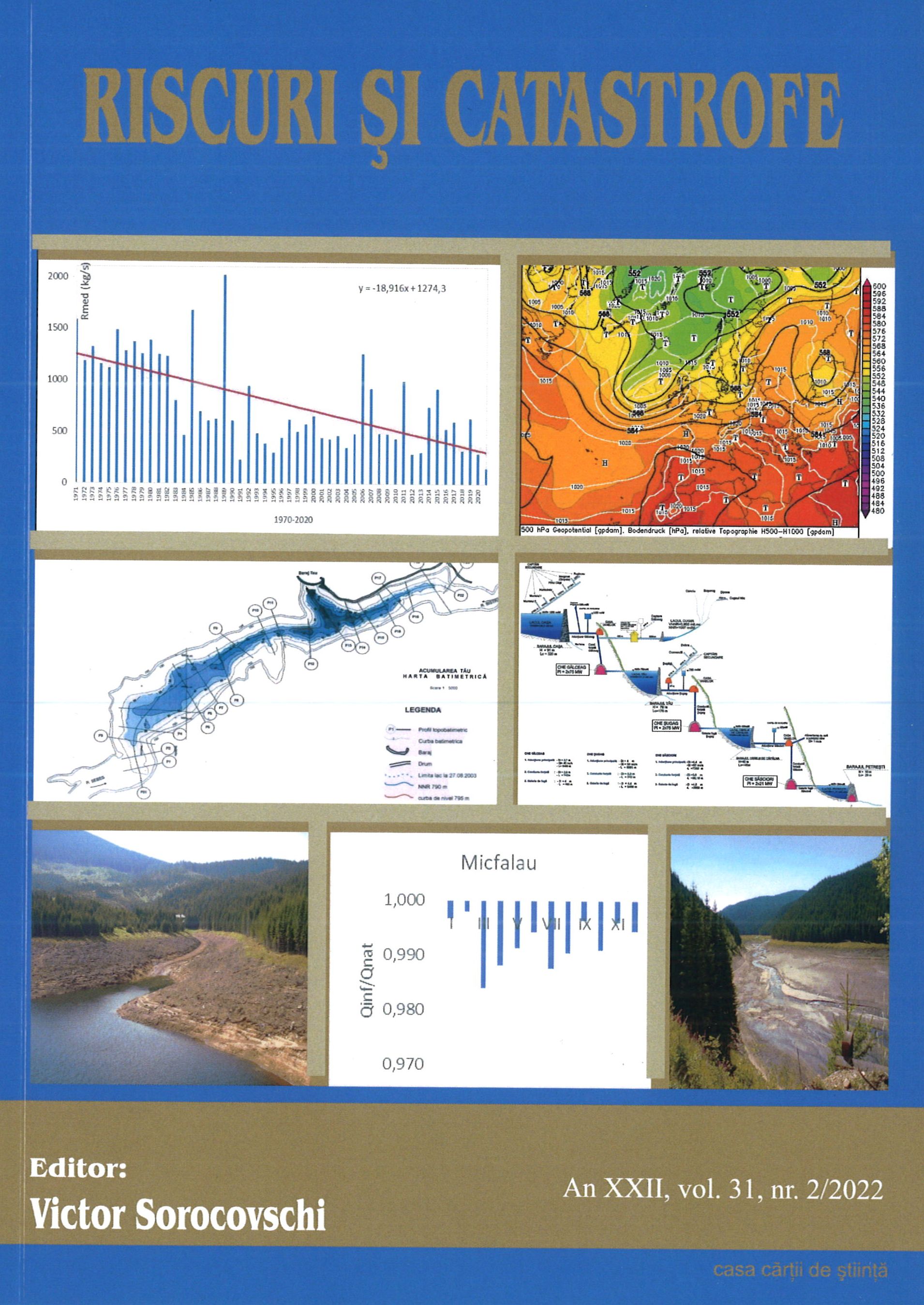
This paper provides an updated analysis of the Danube’s hydrographic, hydrologic, and water quality features describing the characteristics of its entire course and focusing on the lower sector. The Danube is the second largest watercourse in Europe in terms of length (2860 km) and basin area (817,000 km2). In Romania, the Danube is 1,075 km long and drains over 97% of the country’s territory.. The Danube’s multiannual average discharge increases downstream collecting the tributaries waters - 1,470 m3/s at Passau, after the confluence with the river Inn; 1,920 m3/s in Vienna; 2,350 m3/s in Budapest and 5,300 m3/s after the Drava, Tisa, and Sava confluences. The Danube enters Romania at Baziaş with 5,523 m3/s (multiannual average flow during the 1931-2020 period). The maximum discharge is recorded by the high spring waters, but occasionally in summer, too: 15,800 m³/s at Baziaș in April 2006; 15,300 m3/s at Giurgiu, and 15,900 m3/s at Ceatal Chilia. The minimum discharge occurs in autumn and occasionally in winter: 1,040 m3/s at Baziaș in 1949; and 1,790 m3/s at Ceatal Chilia in 1947. The suspended sediments discharge (1840-2000) was on average 53 million tons/ year at Isaccea, that is, 1,681 kg/s. Since 1996, the qualitative monitoring of the water has been implemented through the Danube Transnational Monitoring Network (TNMN) of the International Commission for the Protection of the Danube River (ICPDR). The spatial and temporal variation in the Pontic sector of the physical-chemical quality indicators, reflects the general characteristics and the effect/impact of the main pressures identified at the basin level for the 1996-2020 period, in monitoring stations (from Baziaș to Reni and on its 3 arms). From a complete and integrative perspective and in line with the Water Framework Directive provisions, the Danube water bodies, their typology, ecological status/potential, and chemical status have been presented. The lower Danube-associated natural protected areas that are established under the international, European and national legal requirements have been reviewed.

More...
Reservoir sedimentation in the Sebeș hydrographic basin.

Reservoir sedimentation in the Sebeș hydrographic basin.

Author(s): Iulian Ioan Stef / Language(s): English Issue: 2/2022

The hydro-energetic potential assessment of Sebeş River from the Southern Carpathians through the construction of several dams led to the appearance of Oaşa, Tău, Obreja de Căpâlna and Petreşti Reservoirs. The study of quantitative and qualitative characteristics of lake water was the subject of many articles. This study wants to identify the particularities of the lake sedimentation because the sedimentation rate influences the water quality and the lake’s water volume, in fact the electric energy produced in the lake. For this were analysed the sedimentation sources and the indicators of the sedimentation rate, the sedimentation pace, the dynamic of sedimentation process and the characteristic volumes of each reservoir. Using the measurements made, sedimentation areas with maximum development sectors were highlighted. At the end, was analysed the influence of sedimentation process on the lake’s morphometric elements.

More...
Influenced runoff in the upper and middle basin of the Olt River.

Influenced runoff in the upper and middle basin of the Olt River.

Author(s): Vigh Melinda / Language(s): English Issue: 2/2022

Olt River represents one of the most complex hydrographic system, both in terms of the natural factors of the flow and the uses that influence the natural flow. Hydrometric stations on the main course provide good monitoring of the runoff. The most important uses are water supplies and reservoirs. The analysis refers to the degree of runoff influence and the type of influenced runoff. The degree of runoff influence is analysed at all seven hydrometric stations in absolute and relative values. The type of flow affected indicates relative constancy and does not change along the main course.

More...
An Evaluation of Lidar, EU-DEM and SRTM-Derived Terrain Parameters for Hydrologic Applications in Țibleș and Rodnei Mountains (Romania)

An Evaluation of Lidar, EU-DEM and SRTM-Derived Terrain Parameters for Hydrologic Applications in Țibleș and Rodnei Mountains (Romania)

Author(s): STRAPAZAN CARINA,Kocsis Istvan,Ioan-Aurel Irimus,BÁLINT-BÁLINT LÓRÁNT / Language(s): English Issue: 1/2023

Over the years numerous geospatial data sets have become accessible to users in the form of various types of digital elevation models (DEMs) at different resolutions. DEMs are often used to study the behavior and hydrological response of watersheds, and so came to be considered as a reflection of their physiographic characteristics. Accurate determination of a catchment's morphometric parameters plays a crucial role in distributed hydrological modelling and river flow estimation. This study is divided into two parts and objectives; the first part examines the accuracy of DEMs from different sources (EU-DEM, SRTM and LIDAR) in deriving terrain attributes by comparison, and the second one investigates the ability of resampling the 3 m LIDAR DEM to coarser cell resolutions, to accurately represent the extracted hydrological features. In order to evaluate the quality and precision of SRTM and EU-DEM, the high-resolution 3 m LIDAR DEM was used as a reference data set due to its higher degree of accuracy. Firstly, this data set was resampled to 25 m and 30 m to match the EU-DEM and SRTM cell size, and all of them were re-projected in order to have the same Stereo 70 coordinate system for Romania. A comparison has been carried out between the derived hydrologic and terrain variables of the different DEMs. For the second part of this research, LIDAR DEM was also resampled to 10 m and subsequently, another similar evaluation was made, but this time with regards to different cell resolutions (3 m, 10 m, 25 m and 30 m). Several catchments of various drainage areas (Țibleș, Runc, Sălăuța and Valea Caselor) located in Țibleș and Rodnei Mountains were chosen as study areas for this research. Several resampling techniques available in ArcMap were evaluated, and the comparative analyzes were carried out using the R software. Results revealed not only the LiDAR's superior accuracy as compared to the other data sets, but also the possibilities offered by the latter for deriving the hydrological characteristics of a mountainous area, contingent upon what the user aims to achieve.

More...
The effects induced by the appearance of periods with maximum flow on rivers in the Suceava hydrographic basin

The effects induced by the appearance of periods with maximum flow on rivers in the Suceava hydrographic basin

Author(s): ADRIANA MIHAELA PORCUȚAN / Language(s): English Issue: 1/2023

Floods represent the hydrological hazard that occurs most often around the world and along the human and Earth’s history. Floods affect the natural and anthropic environment, and have positive (nutrients transport, regeneration of underground water resources and ecosystems, etc.) and negative effects. Suceava River basin is an area belonging to the Eastern Romanian Carpathians and Moldavian Plateau that is not that often affected by the negative effects of the maximum water flow, which are the floods. This article tries to present the periods when the floods had negative effects of the studied area. In the interval 1950-2010 where periods when floods were not recorded, but also periods when the negative effects were so evident, that it generated loses of human lives, damages to households and infrastructure, etc.. The most important period with floods was 2005-2010, when the effects were disastrous to the natural and human environment, summing thousands of lei in monetary value.

More...
Analysis of floods in the Cotmeana catchment based on statistical and geographic information systems (G.I.S.) methods

Analysis of floods in the Cotmeana catchment based on statistical and geographic information systems (G.I.S.) methods

Author(s): COSTACHE MIHNEA-ȘTEFAN / Language(s): English Issue: 1/2023

Knowing the characteristics of floods, as well as the risk areas where they can occur, is nowadays of a major importance for the management of watersheds most affected by water-related hazards. This study aims, on the one hand, to analyze the floods produced in the last 5 decades on the Cotmeana river, and on the other hand, to map the zones where the flash floods can occur in the Cotmeana catchment. The Cotmeana River is located in the central-southern part of Romania, being a tributary of the Vedea River. It has a length of 93 km and a basin area of 495 km². The study is based on statistical processing of the hydrological data series from Ciobani hydrometric station on Cotmeana river from 1964 to 2014. The data was provided by the Argeș-Vedea Water Basin Administration (WBA), which includes annual and monthly data of the maximum discharge, as well as hourly discharge series of selected flood events. The floods were analyzed based on their hydrographs and with the help of statistical processing, the return periods of the maximum flows corresponding to the annual floods were calculated. In ArcGisPro environment, the areas susceptible to flash floods were identified and spatialized with the help of a slightly modified version of the Flash Flood Potential Index (FFPI). This index integrates a series of physical-geographic parameters such as slope, lithology, land use, soil texture, density of the hydrographic network, LS factor, etc., thus allowing the determination of the areas with the greatest susceptibility in terms of the production of flash floods. Apart from the morphographic parameters, frequently used in previous studies, in this study, two important factors in the genesis of floods were included in the calculation of the FFPI: rainfall and snow depth, resulting in a higher susceptibility in the north of the basin.

More...
Tarihin İzdüşümünde Antakya (Antiokheia) Kentinin Depremselliği

Tarihin İzdüşümünde Antakya (Antiokheia) Kentinin Depremselliği

Author(s): Laleş Uslu Azarak / Language(s): Turkish Issue: Sp. Issue/2023

Earthquakes are one of the natural phenomena that have been going on since the formation of the world. Earthquakes occurring in fault lines where tectonic plates collide or slide towards each other may be of low intensity or very severe. Many fault lines pass through Turkey, which is located between Eurasia in the north, Arabia and Africa plates in the south. For this reason, many settlements in Turkey are at risk of earthquakes today as in the past. The 7.8 magnitude earthquake that struck southern Turkey (based in Kahramanmaraş) and Syria on February 6, 2023, which can also be called the most destructive earthquakes of recent years, was unfortunately quite destructive and caused many loss of life and property. There is a vital relationship between humans and geomorphology, and this relationship is more prominent in the preference of settlement areas. It is very important to establish a balance between geomorphology and the social needs of communities, to identify and solve geomorphological problems during natural disasters. This study has addressed the geomorphology of this city from a general perspective due to the passage of many fault lines in the geographical location of Antakya, which has been very affected by the earthquakes of 06-20 February 2023 and has seen many destructive earthquakes from the past to the present, but still shows a continuous settlement; important and destructive earthquakes in the past have been examined and scientific findings aimed at minimizing the loss of life and property in possible earthquakes have been examined. Because natural disasters such as earthquakeswill cause less loss of life and property when approached with a scientific understanding.

More...
FLORIN LISOVSCHI, PE DUNĂRE ÎN JOS DE LA IZVOARE LA VĂRSARE

FLORIN LISOVSCHI, PE DUNĂRE ÎN JOS DE LA IZVOARE LA VĂRSARE

Author(s): Carmen Irene Atanasiu / Language(s): Romanian Issue: 5/2023

Review of: Florin Lisovschi, PE DUNĂRE ÎN JOS DE LA IZVOARE LA VĂRSARE, Accent Print, Suceava, 2023 (p. 284).

More...
RUNOFF SIMULATION THROUGH THE NON-PERMANENT ACCUMULATION CIUREA USING HEC-RAS 2D

RUNOFF SIMULATION THROUGH THE NON-PERMANENT ACCUMULATION CIUREA USING HEC-RAS 2D

Author(s): ALEXANDRU TOPOLNICEANU,Ioan Bălan,Claudiu Pricop,Isabela Balan,Catrinel Raluca Giurma-Handley,Loredana Crengăniș / Language(s): English Issue: 23/2023

The paper presents the way of construction a model to simulate the runoff on the Nicolina river, through the non-permanent accumulation Ciurea, Iaşi County. HEC-RAS 2D software was used to create a hydraulic model with detailed two-dimensional unsteady flow river hydraulics calculations on the channel and floodplain. We used gridded data for terrain modeling and a Landcover data layer in the RAS Mapper module, to associate with a specific geometry input file, and a specific results output file. The Storage Area of the basin was defined by an elevation-volume curve. The Boundary conditions were set as outflows from Ciurbeşti and Ezăreni reservoirs, situated on the tributaries and a downstream flow measured at Ia i hydrometric station. The simulated event was the flood corresponding to a near 10% probability of exceedance, that produced on the River Nicolina in July 2013. HEC-RAS 2D software generates results in bidimensional hydrodinamic files that highlights the flow, speed, water level and space expansions of the flooded areas. The bidimensional model is calibrated with reference terms of the measured water level in the modeled area, the maximum limit of the hystorical flood recorded by physical landmarks.

More...
VERIFICATION OF TOPOGRAPHIC DRAWING PARAMETERS OF WATER OUTLETS AT EARTH DAMS

VERIFICATION OF TOPOGRAPHIC DRAWING PARAMETERS OF WATER OUTLETS AT EARTH DAMS

Author(s): VIOLETA DOMINTE (CROITORU),Mihail Luca,NICOLAE MARCOIE,Ioana Agapie (Mereuță) / Language(s): English Issue: 23/2023

The verification of the topographic parameters at the structural components of the earth dams can be requested within the technical expertises. Actions in the foundation ground or those of a hydrological, hydraulic and seismic nature can influence over time the behaviour of some structural components of the earth dams. The case study prepared through a technical expertise on an earthen dam in the Moldova area highlighted a risk in the operation of the evacuator for high flows. The risk is also generated by a series of topographic features of the longitudinal profile identified by topographic measurements. Risk is also influenced by climate change through the formation of maximum flows not considered in design. The results obtained by the hydraulic simulation of the evacuator confirm a possible faulty behaviour of the connecting channel at the transit of the maximum flows. This situation required the creation of new topographic documentation to verify the construction.

More...
The probability of late freezes after the air temperature exceeds 10°C in the territory of the Republic of Moldova

The probability of late freezes after the air temperature exceeds 10°C in the territory of the Republic of Moldova

Author(s): Aliona Botnari / Language(s): English Issue: 1/2023

The agricultural sector has a major social and economic importance for the Republic of Moldova. The aim of the study is to analyze the probability of the occurrence of late frosts on the territory of the Republic of Moldova for the period of 2005-2020, a period in which, from a synoptic point of view, the most obvious effects of climate change were observed on the territory of the Republic of Moldova. Knowing the probability and risk of occurrence of these hazardous climate phenomena is important because it helps farmers decide what, when and where to plant to achieve the maximum possible crop yields. The study aims to map these dangerous manifestations throughout the territory of the Republic of Moldova. Meteorological data regarding the date of the last frost in the air were collected and selected from the archive under the State Hydrometeorological Service. Also, the factual material, regarding the date of the stable passing of the air above 10°C, were calculated in the Climatology and Environmental Risks laboratory of the Institute of Ecology and Geography. The main effort was to analyze temporally and spatially the occurrence of frosts that occurred after the stable passage of air above 10°C. As a result, maps representing the spatial distribution of these frosts were modeled. The temporal distribution was represented in the form of tables. The obtained results will be able to be extended for analysis on physical-geographical regions and territorial administrative units. The spatial and temporal trends in freeze warnings may be of interest to any number of scientists with applied climatological interests.

More...
Trends and variability of extreme climate indices in the Boucle du Mouhoun (Burkina Faso)

Trends and variability of extreme climate indices in the Boucle du Mouhoun (Burkina Faso)

Author(s): Songanaba Rouamba,Joseph Yaméogo,Richard Zongo,Korotimi Sanou,Isidore Pawendkisgou Yanogo / Language(s): English Issue: 1/2023

The main objective of this study is to analyse the trends and variability of extreme weather indices in the Boucle du Mouhoun region of Burkina Faso. To this end, meteorological data for the period 1991 to 2021 were obtained from the National Meteorological Agency of Burkina Faso. These meteorological data (rainfall, temperature) were integrated into the Rclimdex software to generate extreme climate indices (rainfall, temperature). These data were then analysed by means of homogeneity tests (Pettitt and von Neumann ratio), trend tests (Mann-Kendall, Sen's slope) and the frequency of the return period of the extreme climate indices using XLSTAT (Statistical Software for Excel) 2023. The study shows that the precipitation indices are overall homogeneous (p-value ≥ 0.05) and that there is no significance (p-value ≥ 0.05) for the trend of the extreme precipitation indices from 1991 to 2021. Conversely, the temperature indices are not homogeneous (p-value ≤ 0.05), and a significant upward trend was observed for the maximum temperature index (p-value ≤ 0.05) and the minimum temperature index (p-value ≤ 0.05). The extreme climate indices also show considerable variability over the period 1991-2021. Moreover, the return periods for the occurrence of extreme climate indices are shorter, ranging from 0 to 10 years. It is therefore important that regional authorities in the area develop strategies to consolidate water infrastructures and provide financial support to producers, especially banana producers.

More...
A graphic review of studies on microplastic in water

A graphic review of studies on microplastic in water

Author(s): Andrei-Emil Briciu / Language(s): English Issue: 1/2023

There are thousands of scientific studies that deal directly or indirectly with the microplastic in water, from tap water to seawater. The aim of this study is to find the main research interests in the specific scientific literature, based on its most frequent words and by using graphical representations to better understand their linkage. Of interest for most studies are some details or processes around which similar groups of articles are written: the identification of the microplastic type (based on various criteria such as shapes, size, color or chemical composition (e.g.: polypropylene, polystyrene, polyethylene, polyester), the microplastic removal mechanisms (under natural conditions, through deposition, or at wastewater treatment plants), the degree of microplastic contamination in the aquatic environment (e.g.: in oceans or in rivers), the effects of microplastic pollution on various organisms, especially marine life and humans, after microplastic ingestion or food chain alteration. There are already hundreds of reviews that analyze articles dealing directly or indirectly with the problem of microplastics in water; these reviews are interested mostly in defining microplastic categories, abundance, sources and impact. Also, the reviews highlight the need to standardize the sampling and pretreatment methods used when measuring the concentration of microplastics in order to obtain comparable results.

More...
Analyse diachronique des transformations des milieux naturels par régions morphopédologiques dans le Parc National de la Comoé (NordEst de la Côte d’Ivoire)

Analyse diachronique des transformations des milieux naturels par régions morphopédologiques dans le Parc National de la Comoé (NordEst de la Côte d’Ivoire)

Author(s): Sambi Kambire / Language(s): French Issue: 2/2023

This study aims to show the importance of ecosystems degradation of the Comoé national park at the morphopedological regions scale, and the field mechanisms determining the degradation processes. The hypothesis is that the degradation is more pronounced in sandy soils on plateau landscapes made up with granite rocks and are mainly linked to physical circumstances with edaphic significance. From the integrated analysis of landscapes, it appears that “categories” characterized as field/fallow and tree-shrub or grass savanna of the land cover constitute forms of degradation, but with overestimated disturbance rates due to extension of tree-shrub or grass savanna. Regions on tropical ferruginous and sandy ferralitic soils, with very low water retention capacity, resulting from granites, are the most exposed to transformations. To the low water reserve in the soil, it is added the effect of climatic deficits, already important because ˂250 mm, to cause a weaker regeneration of vegetations than in regions on green rocks and shales.

More...
Result 721-740 of 1301
  • Prev
  • 1
  • 2
  • 3
  • ...
  • 36
  • 37
  • 38
  • ...
  • 64
  • 65
  • 66
  • Next

About

CEEOL is a leading provider of academic eJournals, eBooks and Grey Literature documents in Humanities and Social Sciences from and about Central, East and Southeast Europe. In the rapidly changing digital sphere CEEOL is a reliable source of adjusting expertise trusted by scholars, researchers, publishers, and librarians. CEEOL offers various services to subscribing institutions and their patrons to make access to its content as easy as possible. CEEOL supports publishers to reach new audiences and disseminate the scientific achievements to a broad readership worldwide. Un-affiliated scholars have the possibility to access the repository by creating their personal user account.

Contact Us

Central and Eastern European Online Library GmbH
Basaltstrasse 9
60487 Frankfurt am Main
Germany
Amtsgericht Frankfurt am Main HRB 102056
VAT number: DE300273105
Phone: +49 (0)69-20026820
Email: info@ceeol.com

Connect with CEEOL

  • Join our Facebook page
  • Follow us on Twitter
CEEOL Logo Footer
2025 © CEEOL. ALL Rights Reserved. Privacy Policy | Terms & Conditions of use | Accessibility
ver2.0.428
Toggle Accessibility Mode

Login CEEOL

{{forgottenPasswordMessage.Message}}

Enter your Username (Email) below.

Institutional Login